#201 - 5760 Teredo St
Sechelt, BC V0N 3A0
Canada
Sechelt, BC V0N 3A0
Canada
|
#201 - 5760 Teredo St
Sechelt, BC V0N 3A0 Canada |
|
|
FIRST CHART OF TOFINO ON VANCOUVER ISLAND'S WEST COAST: 1790
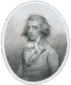
John Meares 1756-1809 SECHELT, BC — NOVEMBER 5, 2008 — Local real estate agent Gary Little has written the following article relating to an historic chart showing the area around Tofino, British Columbia. This is one in a planned series of articles on the history of B.C. to celebrate the sesquicentennial of the founding of the Crown Colony of British Columbia in 1858. This article appeared in edited form in the December 2008 issue of Tofino Time. John Meares, a former Royal Navy lieutenant, was an entrepreneurial fur trader — and part time explorer — on the northwest coast of America in the late 18th century. He was seeking his fortune after reading the official account of Capt. James Cook's third voyage (published in 1784), noting the high prices fetched in China for the sea otter pelts acquired inexpensively during Cook's one month stay at Nootka in 1778. Meares' activities brought him to the west coast of Vancouver Island in 1788. In 1790, after his return to England, he wrote a popular book about his adventures titled Voyages Made in the Years 1788 and 1789, from China to the North West Coast of America. His book included the chart shown here, Esquisse du Port Cox dans le District de Wicananish or, in English, A Sketch of Port Cox in the District of Wicananish. It is the first known chart to show the Tofino, British Columbia area in detail. Tofino is located in Clayoquot Sound on the west coast of Vancouver Island, southeast of Nootka Sound.
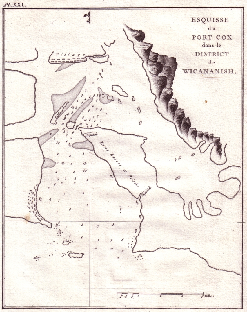
Chart of Tofino Area — 1790 Meares had visited Port Cox for a week in June 1788 in his ship, Felice Adventurer, and here he met the great Chief Wickaninnish of the Tla-o-qui-aht First Nations. The main settlement in the area is now called Tofino, the name given in 1792 by the Spanish explorers Dionisio Alcalá Galiano & Cayetano Valdés in honour of Captain Vicente Tofiño de San Miguel, a rear-admiral in the Spanish navy. Port Cox was named after one of the major investors in Meares' expedition, John Henry Cox, a businessman in Canton, China. The area on the chart marked Village as well as the mountainous area to the east are on an island which was named Meares Island in 1861 by hydrographic surveyor Capt. George Richards aboard the HMS Hecate. The bay near the southern end of this chart is now called Cox Bay.
An original exemplar of this chart, taken from the 1794 French edition of Voyages Made in the Years 1788 and 1789, From China to the North West Coast of America by John Meares, is on display at the offices of Sunshine Coast real estate agent Gary Little in Sechelt, BC.
Gary Little is a realtor® and licensed real estate trading services representative in the offices of Royal LePage Sussex in Sechelt, British Columbia, Canada. He is a former senior software marketing manager, having previously worked in Silicon Valley for almost 20 years at the worldwide headquarters of Apple Inc. and Sun Microsystems, Inc. He is well known for his interactive real estate map of the Sunshine Coast (map.garylittle.ca).
CONTACT INFORMATION
Gary Little, realtor® This news release is located online at: http://www.GaryLittle.ca/maps-historic/tofino1790.html |