Home
Property For Sale (Map)
Property For Sale (List)
Real Estate Statistics
About the Sunshine Coast
Sunshine Coast Links
News Releases
About Me
|
|
GARY LITTLE TEAMS UP WITH THE DISTRICT OF SECHELT TO CREATE FIVE HISTORICAL MARKERS
SECHELT, BC — JANUARY 26, 2009 — Gary Little, a local history enthusiast, has teamed up with the District of Sechelt to create a series of historical markers which highlight important events in the history of the Sechelt area. (See page 2 of the District of Sechelt Community Update for February/March 2009.)
Five markers have been completed and are now on public display:
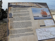
Narváez heritage marker on the Davis Bay Seawall
- José María Narváez: First European Explorer of the Sunshine Coast
Location: South end of the Davis Bay Seawall
This marker recognizes the underappreciated Spanish explorer who, in 1791, was the first European to enter Georgia Strait and sail along the Sunshine Coast. (For more information, see http://www.garylittle.ca/maps-historic/narvaez.html.)
- Early Explorers of the Sunshine Coast
Location: North end of the Davis Bay Seawall
This marker summarizes the activities along the Sunshine Coast of the early Spanish (José María Narváez, Dionisio Galiano, Cayetano Valdés) and British (George Vancouver) explorers in 1791-1792. (For more information, see http://www.garylittle.ca/maps-historic/vancouver.html.)
- The Union Steamship Era: Opening Up the Sunshine Coast
Location: Trail Bay esplanade at the foot of Trail Avenue
Union Steamship was the lifeline for the hardy group of European settlers who first came to the Sunshine Coast. It was later responsible for successfully promoting this area as a desirable tourist destination, using tantalizing descriptions such as the "Gulf Coast Riviera". (For more information, see http://www.garylittle.ca/history/union.html.)
- Origins of Present-Day Sechelt
Location: Trail Bay Pedestrian Pier
This marker illustrates the buildings that were built on Sechelt's waterfront in the first quarter of the 20th century, most of them part of the empire of Sechelt's first big-time entrepreneur, Bert Whitaker.
- Porpoise Bay
Location: Porpoise Bay Wharf
This marker summarizes the early development of industries relating to Sechelt's natural resources: logging, fishing, mining, and farming.
Gary wrote the descriptions and provided the pictures for the first three signs. The last two were put together by Ann Watson, the District's archivist.
“Few people know the important role the Sechelt area has played in the history of British Columbia”, said Gary Little, who is also an expert on the historic maps of Sechelt.
“For example, the first explorer to set foot on the mainland of British Columbia did it right here near Davis Bay in 1791. In the 1920s and 1930s, thanks to Union Steamship, Sechelt became a busy playground for Vancouverites, fueling growth that continues today. These historical markers will help bring deserved attention to Sechelt's place in the history books.”
- * -
Gary Little is a realtor® in the offices of Royal LePage Sunshine Coast in Sechelt, BC. He is well known for his many articles on the history of the Sunshine Coast as well as his interactive maps of the area: a real-estate-for-sale map (map.GaryLittle.ca), a waterfall map (www.GaryLittle.ca/waterfalls/), and a map showing George Vancouver's travels in southwestern BC in June 1792 (www.GaryLittle.ca/van250.html).
—30—
CONTACT INFORMATION
Gary Little, realtor®
Royal LePage Sussex
5485 Wharf Ave., P.O. Box 65
Sechelt, BC V0N 3A0
Cell: 604-741-5347
Office: 604-885-0299
Fax: 604-885-0298
gary@garylittle.ca
www.garylittle.ca
This news release is located online at: http://www.GaryLittle.ca/pr-20090126.html
|