Sechelt, BC V0N 3A0
Canada

|
#201 - 5760 Teredo St
Sechelt, BC V0N 3A0 Canada |

|
|
José María Narváez:
European Discoverer of the Sunshine Coast SECHELT, BC — AUGUST 7, 2008 — Gary Little has written the following article relating to the little-known and underappreciated European discoverer of the site of the City of Vancouver and of the Sunshine Coast, José María Narváez. This is one in a planned series of articles on the history of B.C. to celebrate the sesquicentennial of the founding of the Crown Colony of British Columbia in 1858.

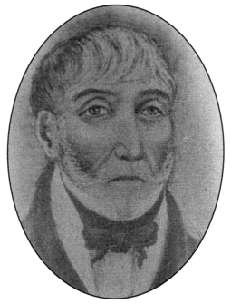
Narváez in his 60s The nominal commander of this historic expedition was Lieutenant Francisco Eliza; however, he remained behind in Discovery Bay (on the southern coast of Juan de Fuca Strait) on the flagship San Carlos while Narváez made his important discoveries. Although not as well known as the three distinguished explorers who arrived one year later (George Vancouver, Dionisio Alcalá Galiano, and Cayetano Valdés), Narváez has the honour of being the first to visit the site of the present day city of Vancouver where he explored English Bay (though not the inner reaches of Burrard Inlet). [2] He was also the first European to cruise along the Sunshine Coast, on July 10-12, 1791. In fact, he was the first to set foot on solid ground there after anchoring off Mission Point near the mouth of Chapman Creek (he named it Rio de la Aguada — River of the Watering Place) so that he could replenish his fresh water barrels from the banks of the river. This is the first recorded landing of an explorer on the southwestern mainland coast of what is now British Columbia.

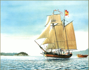
Santa Saturnina off the Sunshine Coast. Courtesy of artist Steve Mayo Here is a reduced image of the entire Carta que comprehende (the actual chart measures 103.5 cm x 63 cm):
Here is a close-up view of the section showing the Sunshine Coast and the Vancouver area:
Notice the anchorages indicated with small anchor symbols near Chapman Creek (Rio de la Aguada) as well as off the western shore of Thormanby Island (Isla de San Ignacio). On this chart, Isla de Zepeda is Point Roberts, Islas de Langara is Point Grey, Punta de la Bodega is likely Stanley Park (even though it appears on the map as part of the north shore), Bocas del Carmelo is Howe Sound, Islas de Apodaca is Bowen Island and nearby islets, and Boca de Moñino is Jervis Inlet. Most of the names given by Narváez to landmarks in Georgia Strait are no longer used because of overwhelming British influence later on. However, three important islands still bear their original names: Texada, Lasqueti, and Ballenas. Unfortunately, Narváez' original journal of this first foray into Georgia Strait has been lost and no copies are known so there is no direct account to illuminate his adventure. All of what is known about his route and his specific discoveries has been gleaned from information shown on the chart (which he helped prepare) as well as second-hand accounts by Francisco Eliza and pilot Juan Pantoja y Arriaga, neither of whom accompanied Narváez into Georgia Strait. [4] Narváez had a long and distinguished career in the Spanish navy. He worked out of the naval station in San Blas, Mexico and retired as a junior captain in 1831, almost 40 years after his historical sail around Georgia Strait. He died in Guadalajara in 1840 at age 72.
Notes [1] See Uncharted Waters: The Explorations of José Narváez (1768-1840) by Jim McDowell (Vancouver: Ronsdale Press, 2015) for a complete biography of Narváez. [2] See Genesis of Vancouver City: Explorations of its site 1791, 1792 & 1808 by Tomas Bartroli (Rev. ed. Vancouver: Tomas Bartroli, 1997) for a detailed analysis of Narváez' exploration of the area around Vancouver. [3] The full title of the chart is Carta que comprehende los interiores y veril de la Costa desde los 48° de Latitud N hasta los 50° examinados escrupulosamente por el Ten[ien]te de Navio de la R[ea]l Armada D[o]n Fran[cis]co Eliza Comandante del Paquebot de S[u] M[ajestad] San Carlos, del porte de 16 Cañones y Goleta S[an]ta Saturnina. (Alias la Orcasitas) Y descubierto nuevamente el Gran Canal de N[uest]ra Señora del Rosario arregladas sus Longitudes al Meridiano de San Blas, y a la ultima Observacion Astronomica hecha en este Puerto de la Santa Cruz de Nuca en este año de 1791 por el Capitan de Navio de la R[ea]l Armada D[o]n Alexandro Malaspina Comandante de las Corbetas de S[u] M[ajestad] la Descubierta y Atrevida. Hechos estos reconocimientos en este año de 1791. The English translation is: Chart of what is known of the interior and line of the coast from latitude 48° N to 50° examined scrupulously for the Lieutenant of the Royal Armada's Navy Don Francisco Eliza commander of His Majesty's packetboat San Carlos, carrying 16 cannons, and the schooner Santa Saturnina. (Alias Orcasitas) And the newly-discovered Gran Canal de Nuestra Señora del Rosario [Georgia Strait] fixing its longitudes to the San Blas meridian, and the last astronomical observation made at the port of Santa Cruz de Nuca [Nootka] in this year of 1791 for the Captain of the Royal Armada's Navy Don Alexandro Malaspina commander of His Majesty's corvettes Descubierta and Atrevida. These accomplishments were achieved in this year of 1791. [4] See Spanish Explorations in the Strait of Juan de Fuca by Henry R. Wagner (Santa Ana: Fine Arts Press, 1933) for English translations of the 1791 reports of Eliza and Pantoja y Arriaga as well as a brief summary written by Juan Carrasco. This news release is located online at:
http://www.garylittle.ca/maps-historic/narvaez.html
|