#201 - 5760 Teredo St
Sechelt, BC V0N 3A0
Canada
Sechelt, BC V0N 3A0
Canada
|
#201 - 5760 Teredo St
Sechelt, BC V0N 3A0 Canada |
|
|
George Vancouver 1757-2007: 250th Birth Anniversary
Survey of the Southwest Coast of BC: June 1792 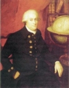
George Vancouver 1757-1798
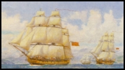
HMS Discovery & HMS Chatham Vancouver's complete survey from California to Alaska — conducted in the summers of 1792, 1793, and 1794 — is often regarded as the most arduous ever undertaken by any mariner. Nevertheless, the charts he published have been widely acclaimed for their detail and accuracy, and were used by seamen well into the 19th century. The map below shows the various places where Vancouver camped for the evening while conducting his survey of southwest British Columbia. It has been created to honour the 250th anniversary of the birth of Vancouver on June 22, 1757 in King's Lynn, Norfolk, England. Also see George Vancouver Visits the Sunshine Coast: 1792 by Gary Little.
Descriptions in the map below are from A Voyage of Discovery to the North Pacific Ocean, and Round the World, Vol. I by George Vancouver (London: Printed for G.G. and J. Robinson and J. Edwards, 1798). To view an online version of the book, go to Open Library.
The dates used here are the same as those mentioned in Vancouver's book. Because there was no international date line at the time, Vancouver's dates are actually one day ahead of the corresponding dates on the calendar we use today. |